")
")
Historian Sigita GASPARAVICIENE
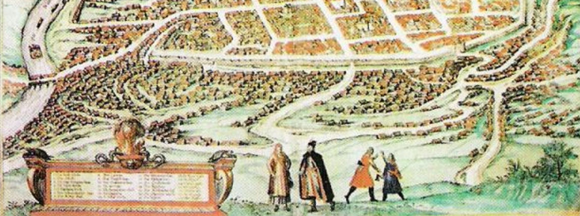
The early 19th c. saw attempts to expand public open spaces in the historical city centre. The Castle Hill with its surroundings – Botanical and Bernardine Gardens, Veršynas (Calf-tender) or Pilies Square, Cathedral Square, and the square in front of today’s National Museum - was to become their nucleus. All of this had already been provided for in the first development 1817 and 1837 city plans. Later 1875 and 1938 official city plans attempted to develop this idea even in a more coherent manner. However, Bekesh, Trijų Kryžių (Three Crosses) and Gediminas’ Grave Hills and the territory of today’s. Kalnų (Hill) Park were only included into this complex of Vilnius Castles Territory as late as the 60s of the 20th c.
Castle Hill and its Surrounding.
The Castle Hill had remained unlandscaped until as late as the 18th c. In the 2nd half of the 18th c. today’s Arsenalo street, leading from the Lower palace to Antakalnis by the stream of Vingrė, was landscaped. A boulevard planted with pyramid poplars was built here and eventually became favourite citizens’ promenading place. After 1830-1831 the boulevard was replaced by trenches of the citadel in the Lower Castle territory. The slopes of the Castle Hill were planted in the 20s of the 19th c. As early as the end of the last century the hill was rather well landscaped. Its curvy paths were planted with trees, with arbours sitting along them. This was the most beautiful and cosy corner of the city. The 30s of the 19th c., with partial restoration of the Gedimino Tower and conservation of the castle ruins, a lawn was built in the yard of the Higher Castle.
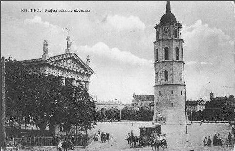
Cathedral Square had no vegetation until the very end of the 19th c. This was the venue for military parades and fairs. At the beginning of the 20th c. a square with a monument of Czarinia Catherine II of the landscape layout was built here. It was enclosed by a row of lime trees and a fine see-through cast-iron fence. In addition to garden designer Pawlowicz, the square design was contributed to by the famous sculptor M.Antokolski. As the result of reconstruction of 1938-1940 done according to designs of the Polish architect R.Gutt, and later of Lithuanian V.Landsbergis-Žemkalnis, the square was replaced by a new square in the shape of the nation’s forum. Its layout included the view of Bekesh,Trijų Kryžių and Gediminas’ Grave Hills, with a flowerbed built in the eastern part (where today’s monument to Grand Lithuanian Duke Gediminas stands), and the square planted with trees on the side of today’s Šventaragio street.
The so called Pushkin’s, or Pilies, Square. In the 16th c. its territory was neighboured by the park of the Lower Castle. After the Lower Castle Palace was torn down, these plots remained abandoned, and this territory and the garden of the Lower Castle Palace were replaced by pastures, hence the name Veršynas, a Calves’ place. In the 20s of the 19th Veršynas and the area north of the Cathedral, formerly included into the Lower Castle, was landscaped and planted – lawns were built and groups of young trees planted surrounded by hedges of decorative bushes. In 1881 this area, then called the Castle garden, was redeveloped and re-landscaped into broad boulevard-type alleys and narrow side paths curved around lawns and groups of planted trees and bushes. It was designed by architect F.Jasinski and gardener of the Verkių palace, owned by Duke Vitgenstein family, H.Pažas. A monument to A. Pushkin was built in 1904, which gave the place the name of Pushkin’s Square. 85 Canadian poplars and 52 chestnut trees were planted here and an alley to the Castle Hill built. On the southern side of the alley to the Castle Hill at the beginning of today’s Pilies Street there was a pond which remained here until the re-landscaping of the square in 1955m. The part of the square from the side of River Neris up to the Cathedral was developed in 1883m. 600 trees were planted there, and lawns and flowerbeds built.
Bernardine (today’s Sereikiškių) Garden. Since the 15th c. the land plot at the foot of Three Crosses and Bekesh Hills surrounded by River Vilnia belonged to the Bernardine Monastery and to the Manvydas Altarija. Until the 17th c. this was a part of a rather densely populated city district Sereikiškės. However, as a result of River Vilnia often changing its course, the location deteriorated.
At the beginning of the 19th c. this area was criss-crossed with straight channels and paths. In the 2nd quarter of the 19th c. the territory acquires the looks of a garden, with a path built along the bank of the Vilnia.
In 1864 the Bernardine Garden was handed over to the city, along with the southern and eastern parts of the old Bernardine Monastery garden by Vilnia. After improvements were made it was allocated for public use. At the end of 3rd quarter of the 19th c. the Bernardine Garden was laid out in the landscape style following the example of the Pinzo Mountain in Rome. The project was assigned through a competition to architect Vizė, the very one who designed Alexander’s Square in St. Petersburg. In 1880, when applications were invited to a new competition for a leisure park project, its conditions required to preserve the trees, springs flowing from the hills, 2 fountains and access roads Stalo (Table), Trijų Kryžių and Bekesh Hills. Vilnius Garden Commission took care of garden maintenance for a few decades. Thanks to its efforts Castle Hill and Tower were maintained and the whole area of the Castle Hill was landscaped.
The Bernardine Garden was re-landscaped to the design of artist A.Strauss in the 80s of the 19th c. The design was based on mixed layout featuring straight main alleys, regularly-shaped squares, planted rows of trees and secondary gracefully curved paths planted with picturesque groups of trees and bushes. Two larger ponds were given a regular shape. One of them was linked to a small irregularly-shapes pond with a bridge built over the canal.
Before World War I the garden had a Summer Theatre, a restaurant, a few pavilions and two fountains. In 1911 on the southern edge of the garden the German hydro-technician Oscar Smreker design a broad network of artesian wells and a pump station. The pump station in the Bernardine (today’s Sereikiškių) Garden was built in 1914. This was the first pump station that is operational up to date. In between the two world wars, fur fairs and the so called Western fairs were held in the Bernardine Garden. The Bernardine garden and all green spaces surrounding the Castle Hill were considered to be a city park. At there time there were ideas to incorporate the Plikąjį (Trijų Kryžių) and Bekesh Hills into the city park complex – they went as far as developing a draft park expansion design.
Botanical Gardens. In the former curve of River Vilnia between Pilies Hill and Sereikiškių Garden, where we have tennis courts today, there used to be the grand duke’s mill with the first Vilnius paper mill set up as early as the the beginning of 16th c. nearby. Until mid 18th c. there were hardly any green spaces in this location. It was part of the city district of Sereikiškės. In 1787 this area was acquired by the Education Commission, which instigated by the famous naturalist G.Forster decided to move Vilnius University Botanical Gardens, then located in the yard of today’s 22 Pilies street, to more spacious Sereikiškės. However, the real founder and developer of the Botanical Gardens was the famous naturalist, Vilnius University Professor S.B.Jundzilas (S.B.Jundzill) (b.1761, d. 1847). As early as the beginning of the 19th c. his efforts resulted in the Botanical Gardens of exemplary maintenance, with their territory divided into quadrangles. Greenhouses and conservatories were built in 1807 (roundabout in the location of today’s Folk Cultural Centre). In 1808 the garden was extended onto the other side of River Vilnia at the foot of Plikojo and Bekesh Hills, where formerly Jesuits had their works of wax candles. The garden was pictorially designed by architect M.Szultz. The garden was adorned with splendid vegetation, canals, bend of River Vilnia, bridges and a small island. The third decade of the 19th c. was the heyday of the garden. The garden gave a push for the development of the Lithuanian botanical science and the start to Vilnius public green spaces and fostering of city landscape.
In 1842, when the Medical Academy was closed down, the Botanical Garden was liquidated. For some time it was the garden of the Governor General. Later a summer residence of the gentry club was set up in the part of the garden at the foot of the Plikojo Hill.
At the end of the 19th c. former Botanical Gardens were converted into entertainment garden with a summer theatre, open stage and the famous Shuman’s restaurant. At the same time it was incorporated into the whole complex of the foot of the Castle Hill. The course of River Vilnia was changed. After World War I a small sports grounds named L.Zeligowski Park and tennis courts were built in the garden. Since 1957 the territory of tennis courts was joined to the then Jaunimo (today’s Sereikiškių) Garden.
The Hill of Three Crosses (Trijų Kryžių), or Plikasis Hill. In the 13th c. the third Vilnius castle, the so called Crooked Castle, used to stand here. In 1390 it was burnt down by the sword-bearers and never rebuilt. The hill is also memorable because seven Franciscans are thought to have died the death of martyrs when pagans, in the absence of Grand Duke Algirdas, tied down to crosses and threw into the rives saying ”swim with the idol that you tell us to worship. Later three crosses were built in commemoration of this event which were regularly renewed in the course of time. In 1916-1918 the fallen down wooden crosses were replaced by bulky concrete built to design of architect A. Wiwulski which eventually became part of Vilnius panorama. Wonderful views of Vilnius open from the Hill. In the after-war years the crosses were blown up, and rebuilt again with the Independence. Over the 16th- 19th c. the Hill belonged to Vilnius Capitula, later to military services. The Hill was incorporated into the territory of Vilnius Castles along with the Kalnų Park only in the 60s of the 20th c.
Bekesh Hill is the next hill behind the Hill of Three Crosses. In 1580 a Hungarian-born friend of Lithuanian Grand Duke Stephen Bator and a military leader Caspar Bekesh who was member of the Antritrinitors Cult was buried here, and a while earlier – in 1579 – another Hungarian military leader Wadush Panonian who was killed at Polock. On the grave of Bekesh S.Bator built a brick monument of octagonal shape. River Vilnia flowing at the foot of the hill was eroding it until in 1838 five walls of the monument fell, and other walls went down in 1841. A small cemetery is thought to have been here in the 17-18th c., and at the beginning of the 20th c. paths leading from the Botanical and Bernardine Gardens to hill top were designed.
Gediminas’ Grave Hill is the next hill in the hill chain surrounding the Castle territory and its green spaces. The legend has it that the Lithuanian Grand Duke Gediminas was buried here, however, no historical sources support this. Only remains of a small 12-13th c. settlement were found here during archaeological excavations. This is a high round hill with steep slopes. On the hill top there is an even landing with a supposed grave of Vilnius founder made of stones in the shape of an altar. The hill was re-landscaped after the Independence in 1989-1990. The stairs and the altar were built then. A broad panoramic view of Vilnius opens from the hill. One can see Gedmino Castle and the Hill of Three Crosses from here.
Kalnų (Hills) Park. This location has up to now been little investigated. It should, however, be of much interest from the historical and archaeological point of view. A settlement of the 13th c. or even older is thought to have been in the amphitheatre of Kalnų Park. Over the 16th –through to the beginning of the 19th c. this territory along with Stalo(Table) Hill belonged to Vilnius Capitula. Later Russian military services built various buildings, military warehouses, etc. here. Its slow redevelopment began in between the world wars. A stadium was built and fitted out here in 1949, and an amphitheatrical Kalnų Park stage surrounded on all sides with hills overgrown with trees – at about 1970. Kalnų Park was incorporated into the Castle territory along with Trijų Kryžių, Bekesh, Gediminas’ Grave and Stalo Hills.